Research
Connecting rivers, coasts and oceans through coupled numerical modeling and artificial intelligence.
We investigate how water, sediment, nutrients and carbon move through connected coastal systems, and how those connections shape flooding, water quality and ecosystem change. Our work spans the Mississippi River Basin and Gulf shelf, with complementary studies of other river-delta systems.
From the basin to the shelf
Rainfall and river discharge connect upstream watersheds to estuaries and coastal seas. Coastal water levels, in turn, influence river and estuary conditions. We study these interactions together rather than treating the river mouth as a fixed boundary.
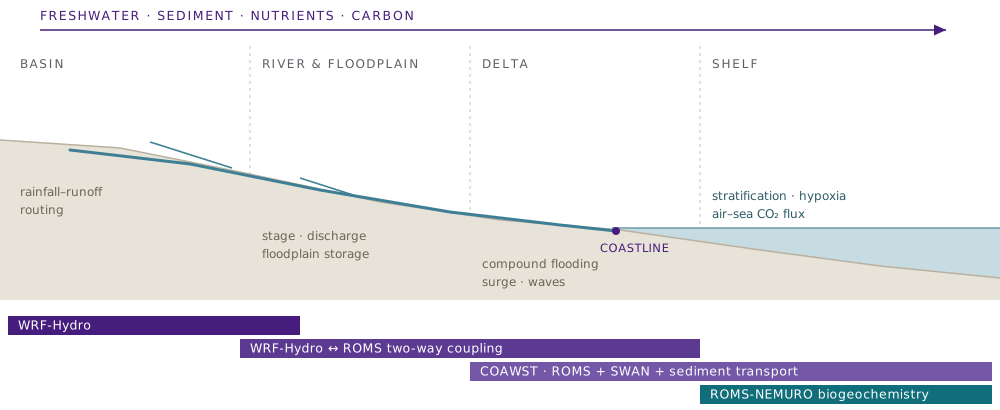
Conceptual model coverage, not a map of operational forecast domains. Watershed models represent runoff and river routing; coupled river-ocean models connect water levels and discharge; coastal models represent waves, sediment, nutrients, oxygen and carbon. Model combinations vary with the research question.
River basin
How do rainfall, land use and river flow control the delivery of freshwater and material to the coast?
Model coverage: WRF-Hydro
Delta and estuary
How do discharge, tides, surge and waves combine to shape flooding, sediment transport and seawater intrusion?
Model coverage: WRF-Hydro and ROMS
Coastal shelf
How do river inputs and ocean circulation affect carbon exchange, oxygen availability and marine ecosystems?
Model coverage: COAWST and ROMS-NEMURO
The modeling framework
Numerical models provide the physical and biogeochemical context. Observations and machine learning help evaluate, interpret and accelerate predictions.
Coupled ocean, atmosphere, waves and sediment
We develop and apply the Coupled Ocean-Atmosphere-Wave-Sediment Transport modeling system (COAWST), including ROMS ocean circulation, WRF atmospheric modeling, SWAN waves and sediment transport. Gulf configurations connect regional circulation with finer-scale coastal processes.
Two-way river-ocean coupling
Coupling WRF-Hydro with ROMS allows exchanges between river and coastal models. This helps us investigate compound flooding and the effects of changing coastal water levels on river-estuary dynamics.
Physical-biogeochemical modeling
Coupled circulation and biogeochemical models represent nutrient cycling, plankton, dissolved oxygen and the carbon system. Applications include hypoxia, air-sea carbon exchange and coastal acidification.
Machine learning and observations
We combine model output and observations with machine-learning approaches for faster flood and hypoxia prediction. Validation against observed conditions remains central to assessing where these methods are useful.
Explore model components and scientific examples | Computing resources
Platform paper: Zhao, Xue and colleagues (2026), GAm-CHFS: an integrated modeling platform for the land-coast-ocean continuum, Environmental Modelling & Software, 204, 107054.
Research themes
Five connected areas of research, from the processes that drive coastal change to the methods that make predictions more useful.
Compound flooding
We examine how rainfall, river discharge, tides, storm surge and waves interact, including nonlinear effects that can be missed when each driver is considered separately.
Storms and sediment
We investigate sediment resuspension, transport and deposition during hurricanes and other energetic events, and their links to coastal change and contaminant redistribution.
Ocean carbon
We study carbon cycling, air-sea carbon dioxide exchange and acidification on river-dominated shelves, including responses to storms, wetland erosion and changing river inputs.
Marine ecosystems
We link circulation, nutrients and oxygen to coastal ecosystem conditions. Research includes hypoxia, plankton dynamics and the growth and dispersal of oyster larvae.
AI and digital twins
We develop hybrid numerical-AI approaches to accelerate prediction and explore digital twins that connect coastal observations, models and visualization. Current applications include spatial flood prediction, daily hypoxia forecasts and a local water-level forecasting pilot.
From research to forecast applications
Our work connects published methods with regional forecasts and community-scale pilot applications. The links below distinguish public forecast products from projects still being evaluated.
GAm-CHFS
Public forecasts
The Gulf of America Coastal Hazards Forecast System provides 72-hour forecasts of river discharge, coastal water levels, currents and waves across the Mississippi Basin and Gulf.
Carbon and hypoxia forecast
Coastal water quality
Physical-biogeochemical modeling connects river inputs with ocean carbon and dissolved oxygen. A hybrid mechanistic-AI approach supports daily hypoxia forecasts over a 72-hour horizon.
Parish-scale flood guidance
Ascension Parish pilot
The LSU-Parish collaboration combines drainage observations, weather forecasts and AI to predict local stream levels over the next 24 hours. The pilot is being tested against observed conditions.
Explore the group
Funded projects | People | Publications | News and media coverage
For research collaborations and questions about model configurations or data, contact Z. George Xue.