Research
Read about the different research themes being studied by the COastal METeorology (COMET) Lab at LSU. Each topic lists the basic questions we're trying to answer, and the places we're studying them. See a list of our recent publications.
Coastal Meteorology
Louisiana: How does the convergence of continental (i.e., Mississippi River watershed), marine
(i.e., hurricanes), and local (i.e., heavy rainfall) in South Louisiana shape the
water resources of th region? 
Timelapse of the May 2025 crest of the Mississippi River at Baton Rouge during major flood stage. Images captured by LSU COMET Lab.
Puerto Rico: How do hurricanes affect land-atmosphere interactions in their wake? How does the abrupt landscape change affect the terrestrial, marine, and atmospheric limbs of the water cycle?
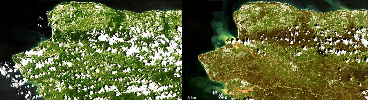
Comparison of pre-Maria landscape and cloud activity versus after the catastrophic defoliation (Miller et al. 2019)
Saharan Dust Transport
Atlantic Ocean and Caribbean: What controls the morphology of large Saharan Air Layer (SAL) events? How do they affect water resources and air quality in the landscapes they impact?
 University Lake on the LSU campus during a Saharan dust outbreak in June 2022 versus
a "normal" day later that same month. Images captured by LSU COMET Lab.
University Lake on the LSU campus during a Saharan dust outbreak in June 2022 versus
a "normal" day later that same month. Images captured by LSU COMET Lab.
Severe Convective Weather
Gulf of America: How does severe convective weather along the Louisiana coast affect offshore energy operations and navigation?
 Model simulation of the mesoscale convective system that capsized an oil rig support
vessel, Seacor Power (green circle), on April 13, 2021 . Taken from Miller et al. (2023).
Model simulation of the mesoscale convective system that capsized an oil rig support
vessel, Seacor Power (green circle), on April 13, 2021 . Taken from Miller et al. (2023).