![]()
2024 LSU-Velocity Risk Gulf of Mexico Hurricane Outlook
Released: June 7, 2024
Plain-Language Summary:
The 2024 LSU-Velocity Risk Gulf of Mexico Hurricane Outlook is the most active forecast yet encountered by the LSU-Velocity team. The Outlook, which is generated using a machine-learning algorithm that pores through months of near-term climate model predictions, is detecting signals that rival the historically busy 2005 and 2020 hurricane seasons. In fact, based on the frequency of favorable conditions compared to more typical seasons, the 2024 LSU-Velocity machine-learning process predicts 14 (+/- 2) tropical cyclones in the Gulf of Mexico (i.e., tropical depressions, tropical storms or hurricanes). However, given that this prediction technique encountered few, if any, years directly comparable to 2024 during its training period, the LSU-Velocity team officially predict 12 storms for its 2024 Gulf of Mexico Hurricane Outlook, lying at the lower end of the predicted range. For context, the 2005 and 2020 hurricane seasons both experienced 11 tropical cyclones in the Gulf of Mexico.
Technical Summary:
- Methodological overview || The LSU-Velocity Risk Gulf of Mexico Hurricane Outlook is based on a unitless metric call the Gulf Hurricane Index (GHI). The GHI is determined by applied a Random Forest machine learning algorithm to daily, Gulf of Mexico-wide averages of 15 metocean variables relevant to tropical cyclone (TC) development (e.g., SST, relative humidity and temperature at multiple pressure surfaces, precipitable water, etc) between June 1 and November 30, 2024. Metocean variables for the upcoming Gulf of Mexico hurricane season are extracted from daily model runs of the Climate Forecast System, version 2 (CFSv2), between May 1-31, 2024. The Random Forest algorithm yields a daily probability of TC (i.e., tropical depression, tropical storm, or hurricane) presence in the Gulf of Mexico, and these daily probabilities are summed acrossed the entire hurricane season. The June-November sums are then averaged for all May 2024 CFSv2 model runs -- yielding the GHI. The GHI is then correlated to a number of days with TCs and number of TC events in the Gulf of Mexico based on historical patterns. See Figure 1 for the performance of the GHI-based forecast between 2011 and 2022.
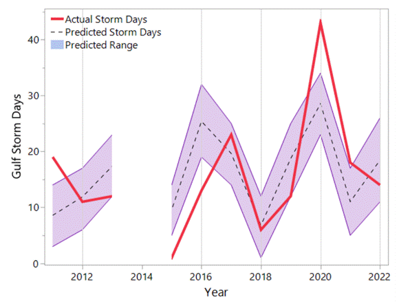
Figure 1. GHI-based prediction of TC days versus observed days with a TC in the Gulf of Mexico between 2011 and 2022
- 2024 Results || The GHI for the 2024 Gulf of Mexico hurricane season is 21.8, the highest GHI calculated since the operationalization of the CFS in 2011. The 95% confidence interval for the 2024 GHI is 20.4 - 23.3. Based on the historical relationship between the GHI and the number of TC days in the Gulf of Mexico (Figure 2), the 2024 GHI corresponds to between 54 and 72 TC days -- which borders on the implausible. In terms of TC events, the GHI, if taken explicitly, points toward 12-16 tropical depressions, tropical storms, or hurricanes in the Gulf of Mexico.
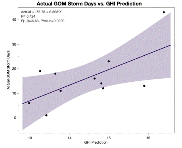
Figure 2. Number of TC days in the Gulf of Mexico versus the GHI. As GHI increases, so do the number of storm days.
- Interpretation of Results || Because the 2024 metocean variables forecast by the May 2024 CFSv2 simulations did not possess a clear historical analog, the GHI value and therefore its TC days and TC events prediction lay beyond the historical range of data upon which it was trained. For instance, the GHI in 2020, another active year in the Gulf of Mexico was 16.4. Because the GHI was extrapolating, rather than interpolating, its historical relationship to a TC frequency, it was interpreted with extra caution. Additionally, the GHI predicted by the CFSv2 runs initialized during late May 2024 was markedly higher than the GHIs generated earlier in the month. Figure 3 shows the marked increase in GHI towards the end of May 2024, and how this trend is not typical of other years -- even 2020. If only the May 1-20 initializations are considered, the 2024 GHI confidence interval declines to 18.4 - 23.3, or 41 - 72 TC days and 10 - 16 TCs. Given these two irregularities, the LSU-Velocity Risk team opted to produce a 2024 outlook on the lower end of the GHI's 95% confidence interval.
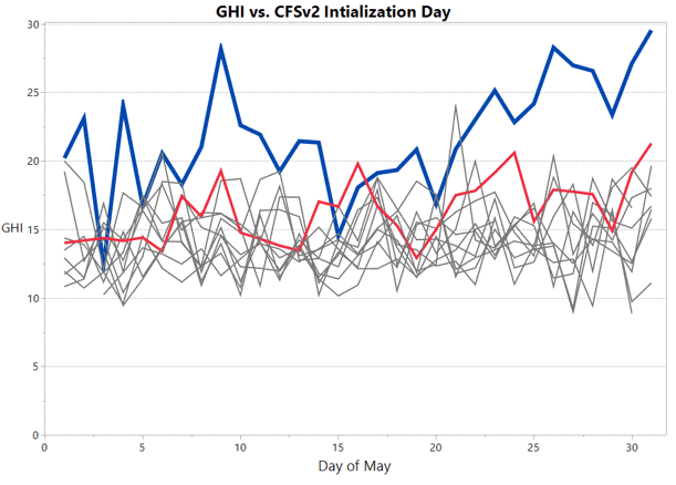
Figure 3. Evolution of the 2024 GHI forecast from the CFSv2 (blue) compared to other years (gray) including 2020 (red).
- Final Forecast || The final 2024 LSU-Velocity Risk Gulf of Mexico Hurricane Outlook is for twelve TCs. For comparison, the 2005 and 2020 hurricanes seasons both hosted 11 such storms in the Gulf. This forecast anchors itself to the historical precedents in the 2020 Gulf of Mexico hurricane season while also acknowledging the favorable TC conditions detected by the GHI (Figure 3), the expected La Nina conditions, and the exceptionally warm SSTs being noted across the North Atlantic and its sub-basins.